Wallkill River Watershed
The Wallkill River Watershed is an interstate drainage basin that covers 1200 square miles in both New Jersey and New York. The headwaters of the Wallkill River originates at Lake Mohawk in Sparta, New Jersey before flowing in a northeasterly direction into New York where it eventually joins the Hudson River in Kingston. The beauty of the watershed and the diversity of land uses, including both rural and suburban residential development, justify the high value that is placed on this watershed area. The watershed suffers, however, from the pressures that impervious areas and unsound agricultural practices place on waterways. This is evidenced by degraded water quality, decreased habitat, streambank erosion, and sedimentation. Specific use impairments have resulted in sections of the Wallkill River being included on the New York and New Jersey 303(d) lists of impaired waterways. In addition, there exists a challenge to coordinate, communicate and coalesce due to the bi-state jurisdictions and political boundaries artificially dividing the watershed.
Upper Paulins Kill Project Area
Through cooperative partnerships with the NJDEP, U.S. Fish and Wildlife Service, U.S. Department of Agriculture-Natural Resources Conservation Service, The Nature Conservancy, the Pinchot Institute for Conservation, and the National Fish and Wildlife Foundation, the WRWMG has been able to expand its scope of work outside of the Wallkill River Watershed to serve a significant portion of the Upper Paulins Kill Watershed in Sussex County. With only light residential and commercial development, the Upper Paulins Kill Watershed is characterized by forests, wetlands, and agricultural properties. As an important tributary to the Delaware River, the Paulins Kill is a focus for restoration because it has been identified by the NJDEP as impaired for fecal coliform/E. coli, total phosphorus, dissolved oxygen, aquatic life, and arsenic at specific locations.
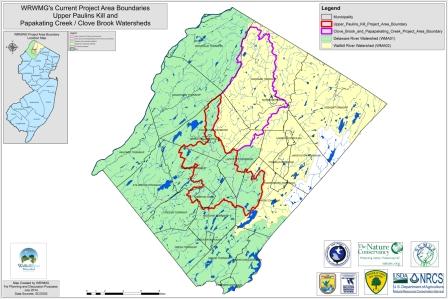
Project Boundary Expansion
The SCMUA-WRWMG has received permission from the NJDEP to officially expand its project boundaries to cover all of Sussex County. Beginning in 2018, the SCMUA-WRWMG will be able to deliver its agricultural outreach, stormwater management, and riparian (streamside) reforestation programs to all Sussex County municipalities. Ultimately, the project boundary expansion will help the WRWMG become a more effective watershed liaison for all Sussex County residents, capable of exploring new project opportunities as they arise to address citizens’ watershed concerns.